Some places feel so visually unfamiliar that they barely register as Earth.
Scientists, filmmakers, and space agencies have long studied many of these sites because their conditions resemble those of environments on Mars, the Moon, or distant exoplanets.
What links these destinations is not just appearance but process. Extreme heat, isolation, chemical reactions, and geological time have shaped environments that operate outside everyday human experience.
For travelers, these places offer a rare opportunity to see how diverse Earth truly is. They also serve as reminders that the planet still holds environments capable of surprising even those who think they have seen it all.
1. Atacama Desert, Chile
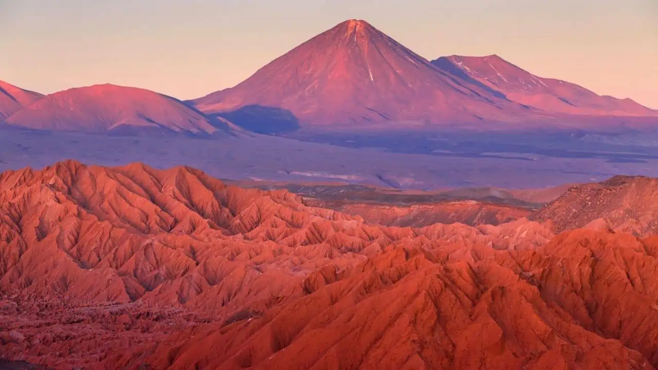
Chile’s Atacama Desert is often considered the driest nonpolar place on Earth. Some weather stations have recorded decades without measurable rainfall, creating terrain that mirrors Martian soil conditions. NASA has used parts of the Atacama to test rover equipment and study microbial survival in extreme dryness.
Salt flats, rust-colored rock formations, and mineral-rich soil are found. The lack of moisture preserves surfaces, giving them a frozen-in-time feel, and the desert takes on an eerie, unearthly appearance that shifts dramatically with changes in light.
The Atacama is a major travel destination with paved roads, tours from San Pedro de Atacama, and no special permits required for most areas. Some research zones are restricted, but travelers can access salt flats, geysers, and desert valleys without issue.
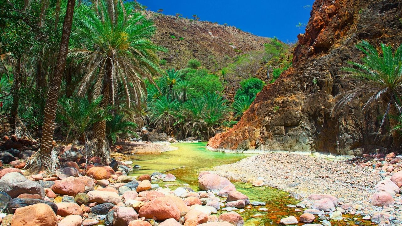
2. Socotra Island, Yemen
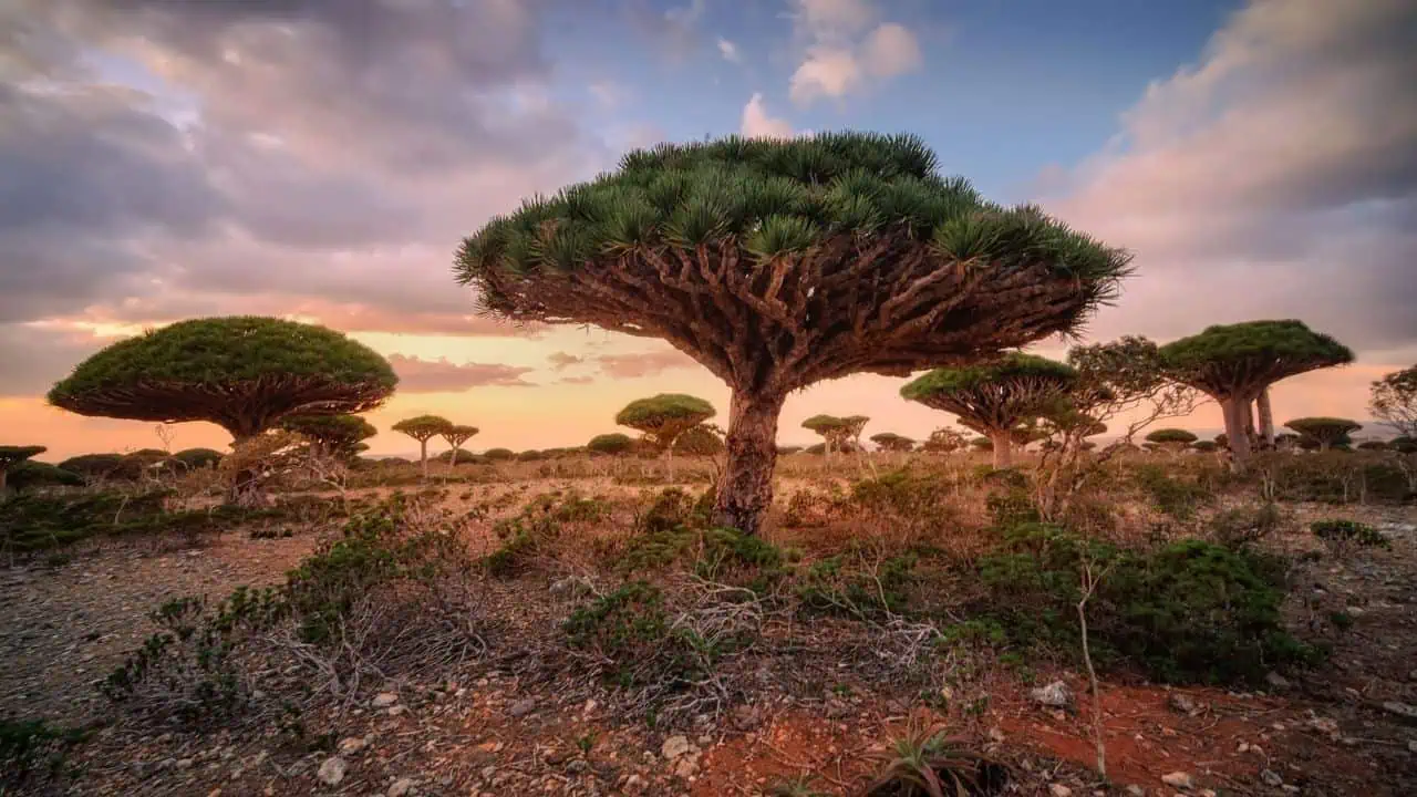
Socotra is home to plant species found nowhere else on Earth, including the dragon blood tree, whose umbrella-like shape and red resin give the island a surreal character. Roughly one-third of its plant life is endemic, the result of millions of years of isolation in the Arabian Sea.
Socotra Island’s limestone plateaus, twisted vegetation, and coastlines create a setting that feels detached from familiar ecosystems. UNESCO recognizes Socotra as a World Heritage Site due to its biological and geological significance.
Socotra is open to tourism, typically via guided tours arranged through approved operators. Travel depends on regional security conditions and flight availability, usually routing through the UAE. Currently, the United States has a “do not travel” warning set for Yemen due to terriorism.
3. Danakil Depression, Ethiopia
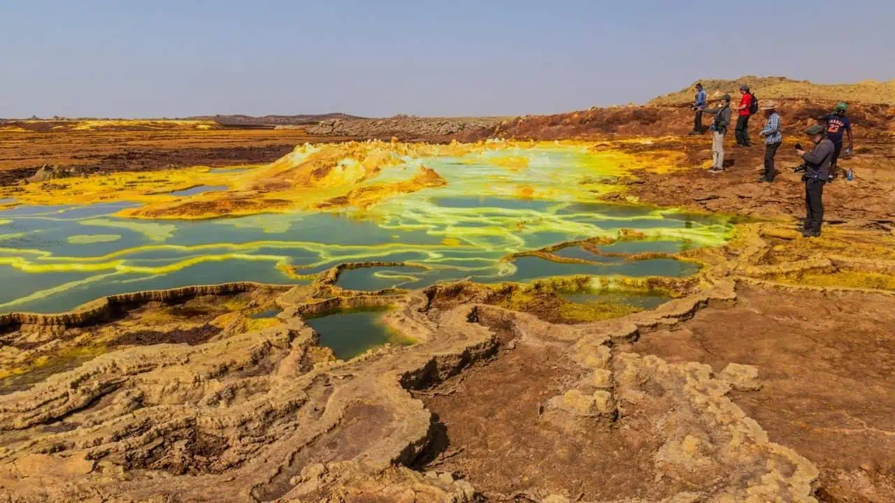
Ethipoia’s Danakil Depression is one of the hottest and lowest places ever found on Earth. It sits below sea level and is shaped by intense volcanic and geothermal activity. Acidic pools, sulfur springs, and neon-colored mineral deposits make up the area.
Temperatures are often above 120°F, and the combination of heat, color, and active lava lakes has led scientists to compare the region to early Earth conditions. It is also one of the few places on earth where three tectonic plates are actively pulling the continent apart.
Visitors can access the Danakil Depression only through guided expeditions due to extreme heat, remoteness, and safety concerns. Travel is tightly controlled and typically organized from Mekele with local authorities.
4. Salar de Uyuni, Bolivia
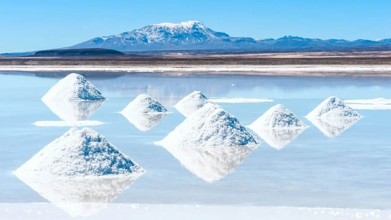
Bolivia’s Salar de Uyuni is the world’s largest salt flat, spanning more than 4,000 square miles. During the dry season, its cracked white surface stretches across the horizon. When raniy season arrives, a thin layer of water turns the flat into a massive reflective plane, blurring the line between sky and ground.
The salt crust formed after prehistoric lakes evaporated, leaving behind a thick layer of salt-rich lithium. The visual effect is so unusual that the area is frequently described as disorienting, mainly when clouds are reflected with near-perfect clarity.
Salar de Uyuni is a major tourist attraction. Visitors travel by 4×4 tours departing from Uyuni. Seasonal conditions affect access, but no special permits are required.
5. Mount Erebus Ice Caves, Antarctica
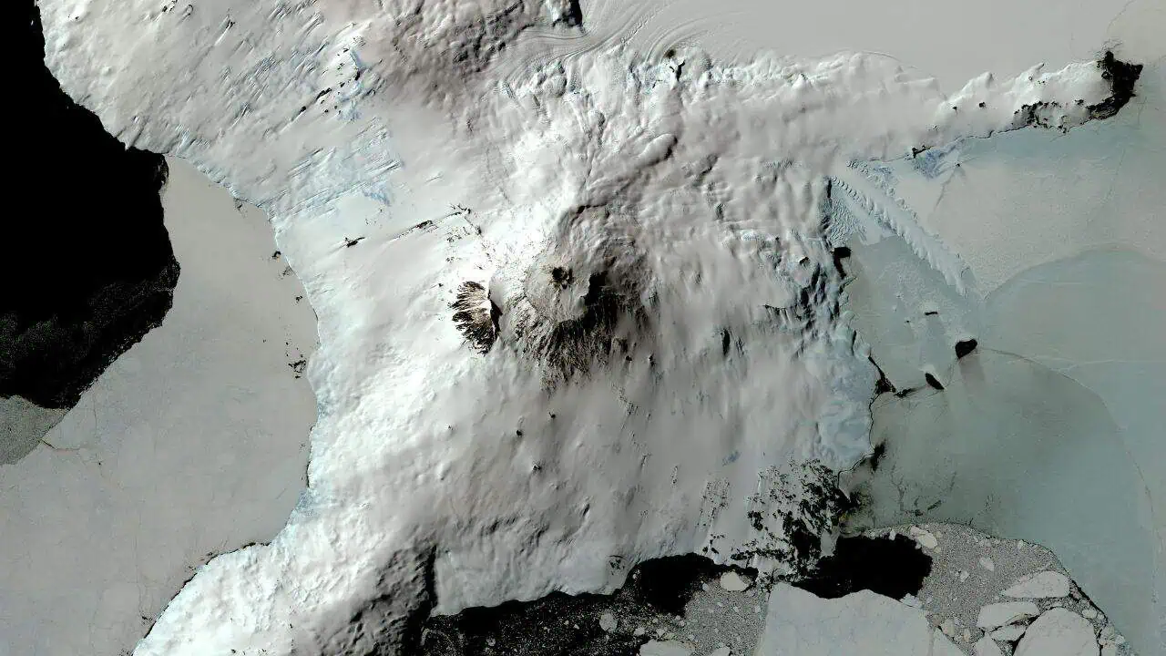
Beneath the slopes of Mount Erebus, an active volcano in Antarctica, steam vents have carved out networks of ice caves. Warm volcanic gases melt chambers into the ice, creating glowing tunnels with translucent blue walls and pockets of heat below freezing surroundings.
Some caves contain microbial life sustained by geothermal energy rather than sunlight, making them of interest to astrobiologists studying potential life on icy moons like Europa or Enceladus.
These ice caves are not accessible to tourists. Antarctica tourism is limited to specific coastal routes, and Mount Erebus lies deep within a restricted scientific zone. Access is reserved for researchers with permits.
6. Wadi Rum, Jordan
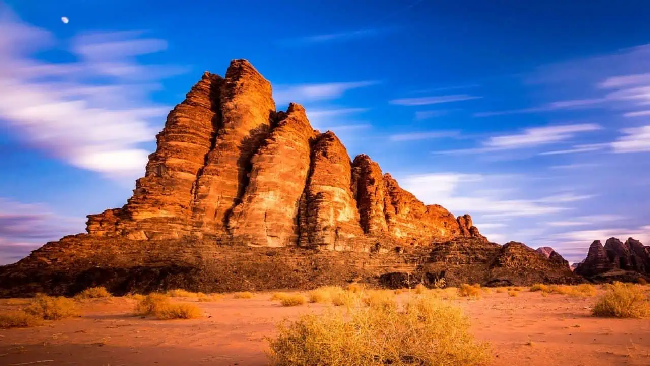
Jordan’s Wadi Rum is a desert valley carved into sandstone and granite. It’s known for towering rock formations, natural arches, and deep red sand. Its Mars-like appearance has made it a popular filming spot for movies like The Martian and Dune.
The geology was shaped by erosion over hundreds of millions of years, producing massive monoliths and narrow canyons. Despite the conditions, archaeological evidence shows humans have lived here for thousands of years.
Wadi Rum is open to visitors. Access requires entry tickets, and most exploration is done with local Bedouin guides. Infrastructure and tourism services are well established.
7. Dallol, Ethiopia
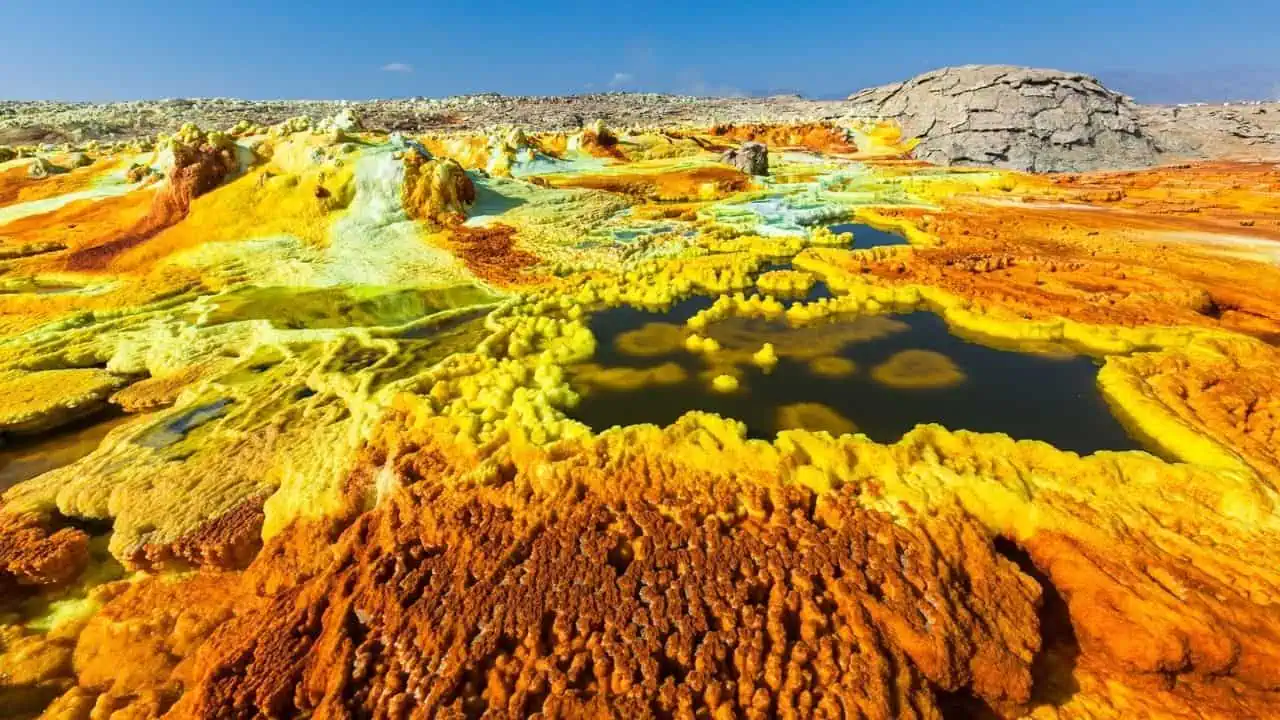
Within Ethipoia’s Danakil Depression, Dallol gets a separate mention for its extreme chemistry. Hydrothermal activity has created pools of acid in shades of yellow, green, and orange, caused by sulfur, iron, and salt deposits reacting with groundwater.
Surface temperatures can reach levels inhospitable to most known life forms, and toxic gases can occur in certain areas. Scientists study Dallol because parts of it may be completely sterile, offering insight into the limits of life on Earth and beyond.
Dallol is one of the most hazardous places on Earth. Access fluctuates due to safety conditions, toxic gases, and regional security. When open, visits are only possible with authorized guides and permits, and closures are common
8. Zhangye Danxia, China
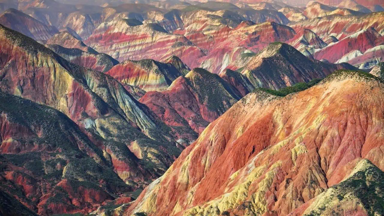
Zhangye Danxia is made up of layered rock formations that display bands of red, yellow, green, and purple. These colors result from mineral deposits laid down over millions of years, then uplifted and eroded into sharp ridges and valleys.
The patterns appear almost artificial from a distance, as if painted rather than formed naturally. The site is protected as a national geopark and remains one of the clearest examples of how sedimentary processes can create otherworldly visuals.
The site is a national geopark with boardwalks, viewing platforms, and regulated visitor access. It is one of the most accessible locations on this list.
9. Lake Hillier, Australia
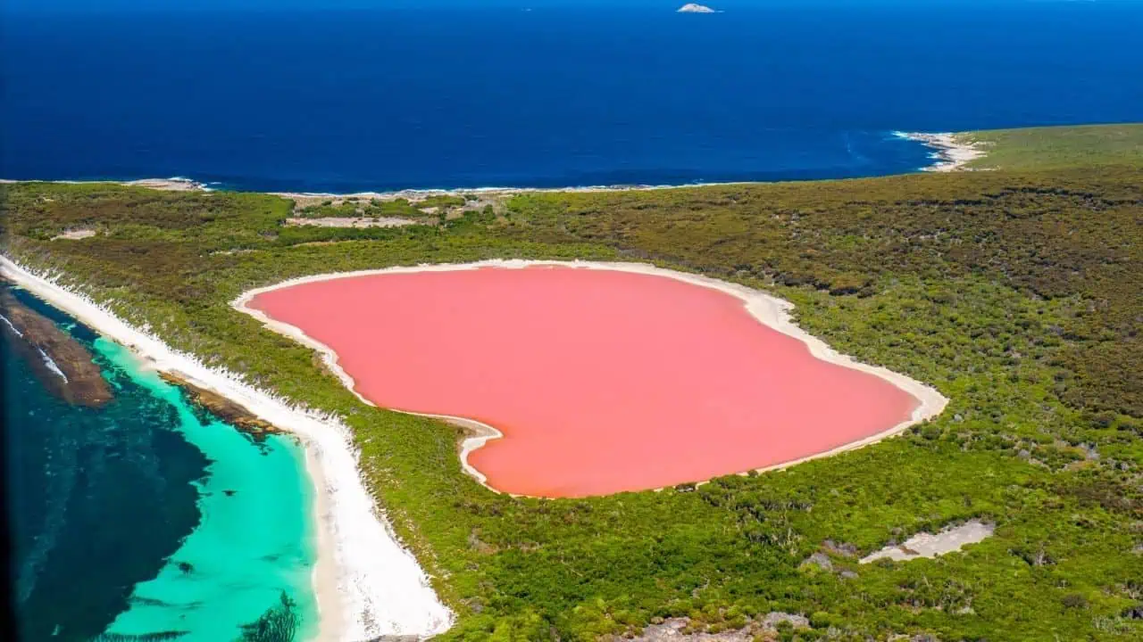
Lake Hillier is a bright pink lake on Middle Island off the coast of Western Australia. Unlike seasonal color changes seen in other lakes, Hillier’s pink hue remains consistent year-round.
Scientists attribute the color to microorganisms that produce pigments in response to the lake’s high salinity. The sharp contrast between the pink water, white salt rim, and deep blue ocean nearby makes the lake appear almost synthetic when viewed from above.
You cannot swim or walk directly along the lake. The primary way to see Lake Hillier is by scenic flight or boat, as the surrounding land is protected and difficult to access on foot.
10. Namib Desert, Namibia
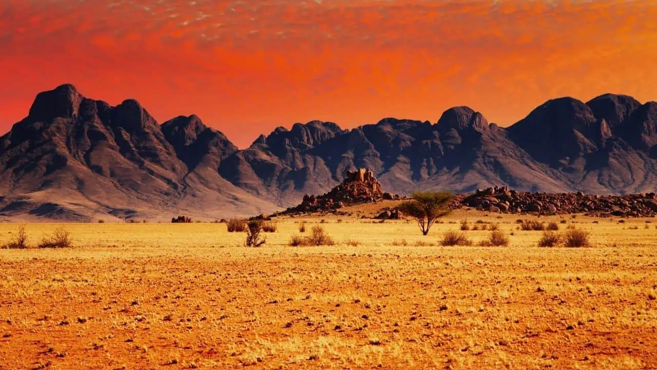
Namibia’s Namib Desert is one of the oldest on Earth, with sand dunes estimated to be over 50 million years old. Some dunes rise more than 1,000 feet and shift color throughout the day, moving from pale orange to a deep deep red.
Along the Skeleton Coast, fog from the Atlantic Ocean drifts inland, sustaining limited life in an otherwise arid environment. The scale, age, and isolation of the desert contribute to its reputation as one of the most forgein places on the planet.
Large areas of the Namib Desert are accessible via national parks such as Namib-Naukluft. Some remote zones require permits or guided travel, but key dune regions are open to visitors.

Alexandrea Sumuel Groves is a Travel Journalist, Yahoo! Creator, MSN Partner, a member of both the Society of Professional Journalists and North American Travel Journalists Association, and the founder of Wander Worthy. She covers vacation destinations, travel news, and tourism trends.


